Rim Fire Update – August 21

GOES-15 visible (left) and shortwave infrared (right) imagery (click image to play animation)

GOES-15 visible (left) and shortwave infrared (right) imagery (click image to play animation)

As the Rim Fire continues to burn near Yosemite National Park in California on August 21st, 2013, another pyrocumulonimbus has spawned from the complex. Looking at the GOES-15 visible imagery (above, left; click image to play animation), a large plume of cloud can be seen erupting from the fire, centered approximately at 38N 120W, at about 22 UTC. The GOES-15 shortwave infrared imagery (above, right; click image to play animation), depicts a large hot spot (red pixel enhancement) at the source point of this pyroCb plume.

GOES-15 longwave infrared imagery (click image to play animation)

GOES-15 longwave infrared imagery (click image to play animation)

The GOES-15 longwave infrared imagery (above; click image to play animation) shows the cloud top brightness temperature values of the pyroCb as it is whisked off to the northwest. The pyroCb–indicated by the thin green-colored strip emanating from the source fire at ~22:30 UTC–has a brightness temperature of about -40º Celsius near its time of birth and a brightness temperature closer to -50º C as it drifts further northwest, conglomerating with another convective system.

MODIS true-color and false-color Red/Green/Blue (RGB) images

MODIS true-color and false-color Red/Green/Blue (RGB) images

The pyroCb event was captured by AQUA, one of the two MODIS polar-orbiting satellites. Looking at the true-color and false-color MODIS imagery (above), one can see not only impressive span of the fire (indicated by the charred-red color in the false-color imagery), but also a large plume of smoke and cloud rising from fire complex.

Miner Paradise Complex PyroCB in Montana

GOES-14 Visible (top) and Shortwave IR (bottom) Imagery (click image to play animation)

GOES-14 Visible (top) and Shortwave IR (bottom) Imagery (click image to play animation)

A PyroCB event occurred in Montana on August 19, 2013, as seen with GOES-14 imagery. A two-panel comparison (above; click image to play animation) shows the visible imagery (top panel) as well as the shortwave infrared imagery (bottom panel). Hot spots are already apparent in Wyoming, and around 20:45 UTC, a hot spot flares up in southern Montana, just above the Wyoming-Montana border at a latitude/longitude of 45.2 degrees North and 110.7 degrees West. In the visible imagery, smoke becomes more apparent at about 21:45 UTC, and the PyroCB begins forming around 22:50 UTC.

GOES-14 Longwave Infrared Imagery (click image to play animation)

GOES-14 Longwave Infrared Imagery (click image to play animation)

On the GOES-14 long wave infrared imagery (above; click image to play animation), light blue pixels can be spotted around 23:00 UTC, indicating cloud top temperatures of about -20 degrees Celsius. Soon after this, the cloud tops reach about -30 degrees Celsius (dark blue enhancement). For a brief moment at about 23:20 UTC, one can spot dark green pixels, which indicate that the cloud tops may have reached between -30 and -35 degrees Celsius. At this temperature, the cloud tops were at least partly glaciated.

PyroCb from Rim Fire Complex, CA

…Note: scroll down to the bottom of this post for 22 August and 23 August updates…

GOES-14 SRSO visible (left) and shortwave IR (right) imagery (click image to play animation)

GOES-14 SRSO visible (left) and shortwave IR (right) imagery (click image to play animation)

On August 19, 2013, the Rim Fire complex in Groveland, CA spawned a pyrocumulonimbus cloud as it burned through the Stanislaus National Forest. The GOES-14 satellite was also placed into Super Rapid Scan Operations for GOES-R (SRSO-R) for the day, providing imagery at 1-minute intervals. Taking a look at the GOES-14 visible imagery (above, left; click image to play animation), a white plume (our soon-to-be pyroCb) can be seen erupting from the fire complex in the center of the image at around 23 UTC. The fire complex becomes enveloped by convection from the east as the evening progresses, but the path of the initial “pyroburst” (see previous blog post) can be seen throughout. As this plume drifts to the northwest, it develops into a pyroCb, casting a shadow over some lower-level clouds. Taking a look at the GOES-14 shortwave IR imagery (above, right; click image to play animation), the pyroCb (lighter pixels) can be seen emanating from the fire complex (red pixels). The red pixels to the south and southeast at the beginning of the animation are not wildfires; rather, these pixels indicate extreme temperatures at ground level, which are not uncommon in the western US at midday during the summer.

GOES-14 SRSO longwave IR imagery (click image to play animation

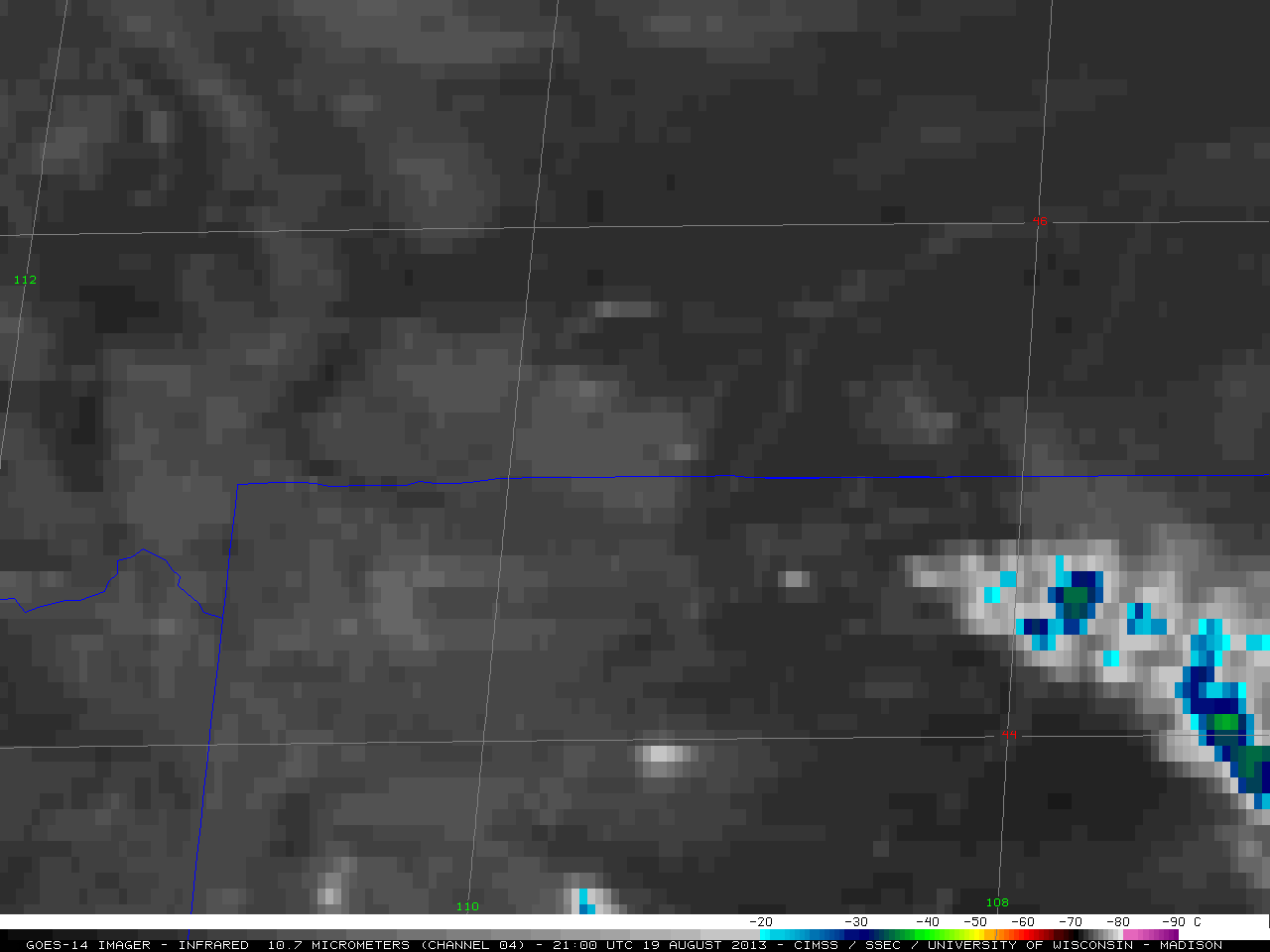
GOES-14 SRSO longwave IR imagery (click image to play animation)

The GOES-14 longwave IR imagery (above; click image to play animation)shows the evolution of the pyroCb’s cloud-top temperatures over time. At the time of its conception, at ~23 UTC, the cloud top temperatures average around -30 degrees Celsius (dark blue color enhancement). By the time the pyroCb is due west of Lake Tahoe (0:45 UTC on Aug 20), temperatures are as low as -50º C (yellow/orange color enhancement). As the pyroCb drifts further north, above the lower-level clouds, temperatures approach -60º C (red color enhancement).

===== 22 August Update =====

Suomi NPP VIIRS 3.74 µm shortwave IR and 0.7 µm Day/Night Band images

Suomi NPP VIIRS 3.74 µm shortwave IR and 0.7 µm Day/Night Band images

A night-time (10:01 UTC or 3:01 AM local time) comparison of AWIPS images of Suomi NPP VIIRS 3.74 µm shortwave IR and 0.7 µm Day/Night Band data (above) showed signatures of the Rim Fire which had been burning since 17 August near Yosemite National Park in California. On the shortwave IR image, numerous “hot spots” (black to yellow to red enhancement) revealed the location of larger, hotter fires that were burning along the periphery of the large burn scar. The Day/Night Band image showed (1) a bright white glow over the area of active fires, and (2) light gray signatures of the primary middle to upper altitude smoke plume that was moving northward, in addition to an area of lower altitude smoke that was moving westward toward lower elevations. Due to ample illumination from a 98% full waning gibbous Moon phase, the “visible image at night” capability of the Day/Night Band proved to be useful for identifying the location of the smoke plumes.

Later that day during the afternoon hours the Rim Fire exhibited very active growth, nearly doubling in size to over 105,000 acres (Wildfire Today | InciWeb). A comparison of 250-meter resolution MODIS true-color and false-color images from the SSEC MODIS Today site (below) showed the large and very dense smoke plume at 18:42 UTC (11:42 AM local time).

MODIS true-color and false-color Red/Green/Blue (RGB) images

MODIS true-color and false-color Red/Green/Blue (RGB) images

The GOES-14 satellite had been placed into Super Rapid Scan Operations for GOES-R (SRSO-R) mode, providing images at 1-minute intervals during the entire day. A sequence of these GOES-14 SRSO-R 0.63 µm visible channel images (below; click image to play animation) showed that the initial northward motion of the smoke plume began to transition to a more northeasterly motion after about 17 UTC. This was due to a shift in the winds aloft as a semi-stationary cut-off low just west of the coast of California began to move northward during the day.

GOES-14 0.63 µm visible channel images (click image to play animation)

GOES-14 0.63 µm visible channel images (click image to play animation)

The  change in the winds aloft which allowed the smoke plume to begin drifting more toward the northeast prompted the National Weather Service forecast office at Reno, Nevada to amend their forecasts for some areas to include smoke and haze (complete AFD):

AREA FORECAST DISCUSSION
NATIONAL WEATHER SERVICE RENO NV
207 PM PDT THU AUG 22 2013

ONLY MINOR CHANGES MADE TO ONGOING FORECAST WITH THE GREATEST CHANGE TO ADD SMOKE AND HAZE DUE TO MULTIPLE ONGOING WILDFIRES, THE GREATEST CONTRIBUTOR BEING THE RIM FIRE JUST WEST OF YOSEMITE. THE UPPER LEVEL LOW WHICH HAS BROUGHT US PLENTY OF THUNDERSTORMS THE PAST FEW DAYS IS BEGINNING TO LIFT NORTH WITH A DRIER  SOUTHWEST FLOW RESULTING ACROSS NORTHEAST CALIFORNIA AND NORTHWEST NEVADA.

Surface visibilities at locations such as South Lake Tahoe were reduced as low as 1.25 miles once the smoke plume began to move over that area.

===== 23 August Update =====

Night-time Suomi NPP VIIRS 3.7 µm shortwave IR images on 21, 22, and 23 August

Night-time Suomi NPP VIIRS 3.7 µm shortwave IR images on 21, 22, and 23 August

Suomi NPP VIIRS 3.74 µm shortwave IR images on 3 consecutive nights (21, 22, and 23 August) showed the rapid increase in size of the Rim Fire (above).

Another example of smoke from the Rim Fire being detected during the night-time hours can be seen at 09:43 UTC or 2:43 AM local time on 23 August (below). The VIIRS 0.7 µm Day/Night Band image revealed a number of discrete plumes of smoke streaming northward, then northeastward toward the Lake Tahoe area. At South Lake Tahoe the surface visibility at the time of the image was 2 miles, but it decreased to 1/2 mile four hours later.

Suomi NPP VIIRS 0.7 µm Day/Night Band and 3.74 µm IR channel images

Suomi NPP VIIRS 0.7 µm Day/Night Band and 3.74 µm IR channel images

“Pyrobubbles” originating from fires in the northwestern US

GOES-15 0.63 µm visible channel images (click image to play animation)

GOES-15 0.63 µm visible channel images (click image to play animation)

Mike Fromm (NRL) coined the term “pyrobubbles”, and pointed out 3 examples that occured on 16 August 2013. We shall examine each of thse 3 cases using GOES-15 (GOES-West) imagery. The first pyrobubble originaled from a fire near the Idaho/Montana border; GOES-15 0.63 µm visible channel images (above; click image to play animation) showed the appearance of a distinct pyroCu cloud at 21:41 UTC, from which emanated a brief burst of smoke which moved rapidly eastward as it spread out over western Montana (moving over Helena KHLN around 01:00 UTC).

The corresponding GOES-15 10.7 µm IR channel images (below; click image to play animation) showed the smoke plume exhibited an IR brightness temperature of -20º C (cyan enhancement) near the fire source region at 22:00 UTC, reaching a minimum of -38º C (light green enhancement) over western Montana at 00:30 UTC.

GOES-15 10.7 µm IR channel images (click image to play animation)

GOES-15 10.7 µm IR channel images (click image to play animation)

==========

GOES-15 0.63 µm visible channel images (click image to play animation)

GOES-15 0.63 µm visible channel images (click image to play animation)

The second case occured farther south over southern Idaho; GOES-15 0.63 µm visible channel images (above; click image to play animation) revealed a well-defined pulse of pyroCu smoke which was ejected upward through the lower elevation smoke pall at 23:41 UTC.This pulse of smoke then spread out as it moved rapidly eastward across Idaho.

The corresponding GOES-15 10.7 µm IR channel images (below; click image to play animation) showed that this smoke feature first exhibited an IR brightness temperature of -20º C (cyan enhancement) at 23:00 UTC, reaching a minimum of -37º C at 00:30 UTC.

GOES-15 10.7 µm IR channel images (click images to play animation)

GOES-15 10.7 µm IR channel images (click images to play animation)

==========

GOES-15 0.63 µm visible channel images (click image to play animation)

GOES-15 0.63 µm visible channel images (click image to play animation)

The third event was over northern Utah; GOES-15 0.63 µm visible channel images (above; click image play animation) first showed the pyroCu-induced upward pulse of smoke just south of the Great Salt Lake at 22:30 UTC. Similar to the previous 2 events, this pulse of smoke then raced rapidly eastward away from the source region.

The corresponding GOES-15 10.7 µm IR channel images (below; click image to play animation) showed this smoke feature did not exibit IR brightness temperatures as cold as the other 2 cases — values between -20º C and -25º C were briefly seen from 23:00 to 23:30 UTC.

GOES-15 10.7 µm IR channel images (click image to play animation)

GOES-15 10.7 µm IR channel images (click image to play animation)

Salt Lake PyroCb Event

GOES-15 visible (left) and infrared (right) images (click image to play animation)

GOES-15 visible (left) and infrared (right) images (click image to play animation)

Sparked on Saturday, August 11, the Tooele County wildfire continued to burn through Wednesday, August 14, belching a large amount of smoke into the atmosphere. GOES-15 visible imagery (above, left panel; click image to play) depicts a fair amount of smoke being ejected from the fire and a small pyrocumulonimbus cloud forming rapidly near the end of the day. Smoke from the Idaho fires can also be seen in the northwest corner of the image. The GOES-15 shortwave infrared imagery (above, right panel; click image to play) shows a strong heat signature in the vicinity of the fire (enhanced red pixels) that persists both before and during the pyroCb event.

GOES-15 longwave infrared image (click image to play animation)

GOES-15 longwave infrared image (click image to play animation)

The GOES-15 10.7 micron longwave infrared imagery (above; click image to play) shows the cloud-top temperatures of the small pyrocumulonimbus. These temperatures range between -30 and -40 degrees Celsius, indicating a fair amount of convection for this young fire.

GOES-14 1-minute interval imagery of Idaho pyrocumulonimbus

GOES-14 0.63 µm visible (left) and 3.9 µm shortwave IR (right) images (click image to play animation)

GOES-14 0.63 µm visible (left) and 3.9 µm shortwave IR (right) images (click image to play animation)

The GOES-14 satellite was placed into Super Rapid Scan Operations for GOES-R (SRSO-R) mode on 13 August 2013, providing imagery at 1-minute intervals. The development of a well-defined pyrocumulonimbus (pyroCb) cloud produced by a large fire burning to the east of Boise in southern Idaho can be seen in a comparison of GOES-14 0.63 µm visible channel and 3.9 µm shortwave IR channel images (above; click image to play animation). The hottest pixels in the shortwave IR images are enhanced with a red color.

Judging from 250-meter resolution MODIS true-color and false-color images from the SSEC MODIS Today site (below), the pyroCb was spawned by fires burning along the eastern/northeastern periphery of the large burn scar (which appears as the  red to brown feature on the false-color image) of the merged Pony and Elk Fire Complexes.

MODIS true-color and false-color images

MODIS true-color and false-color images