PyroCB Event in Idaho on August 12th 2013

GOES-15 visible and shortwave IR images (click image to play animation)

GOES-15 visible and shortwave IR images (click image to play animation)

A brief pyrocb event was seen on GOES-15 imagery on August 12, 2013. A two-panel comparison of GOES-15 visible and shortwave IR images (above; click image to play animation) showed numerous hot spots (red enhancement on shortwave IR) at latitude/longitude of 43.8 degrees North and 114.5 degrees West. On the visible images, there was also evidence of a pyrocb anvil. Hot spots were not apparent on the following day.


GOES-15 IR image (click to play animation)

GOES-15 IR image (click to play animation)

On the GOES-15 IR images (above; click to play animation), the cloud top temperatures of -40 degrees Celsius or colder (green enhancement) were evident, which indicates that the cloud tops were glaciated.

Backward Air Mass Trajectories

Backward Air mass Trajectories

According to CALIPSO lidar data, the smoke was injected to an altitude of around 10 km and was transported northeastward into Canada.

Fires in southern Idaho

GOES-15 (left) and GOES-13 (right) 0.63 µm visible channel and 3.9 µm shortwave IR channel images (click image to play animation)

GOES-15 (left) and GOES-13 (right) 0.63 µm visible channel and 3.9 µm shortwave IR channel images (click image to play animation)

A cluster of 4 major fire complexes (Pony, Elk, McCan, and Beaver Creek) east of Boise in southern Idaho began to exhibit extreme fire behavior on during the afternoon and evening hours on 10 August 2013. A comparison of GOES-15 (GOES-West) and GOES-13 (GOES-East) 1-km resolution 0.63 µm visible channel and 4-km resolution 3.9 µm shortwave IR images (above; click image to play animation) showed 2 different perspectives of the many dense smoke plumes and the eventual development of a well-defined pyrocumulonimbus (pyroCb) cloud whose source appeared to be the Elk Complex. On the shortwave IR images, the hottest fire pixels are enhanced red. These fires were belived to have been caused by lightning on 08 and 09 August.

The corresponding 4-km resolution GOES-15 and GOES-13 10.7 µm IR channel images (below; click image to play animation) revealed that the pyroCb cloud first began to exhibit IR brightness temperatures colder than -20º C  (cyan color enhancement) after 20:00 UTC or 1:00 PM local time, -40º C (green color enhancement) after 20:20 UTC or 1:30 PM local time, and -60º C (darker red color enhancement) after 00:30 UTC or 6:30 PM local time.

GOES-15 (left) and GOES-13 (right) 10.7 µm IR channel images (click image to play animation)

GOES-15 (left) and GOES-13 (right) 10.7 µm IR channel images (click image to play animation)

250-meter resolution MODIS true-color and false-color Red/Green/Blue (RGB) images from the SSEC MODIS Today site (below) offered a very detailed view of the gray-colored smoke plumes streaming northward from the various fire complexes, as well as the brighter white pyrocumulonimbus cloud which was being produced by the Elk Complex.On the MODIS false-color image, the large fire burn scars showed up as darker shades of red, while the actively-burning fires appeared lighter red to white.

MODIS true-color and false-color RGB images

MODIS true-color and false-color RGB images

Several hours later, a comparison of 1-km resolution Suomi NPP VIIRS 3.74 µm and 4-km resolution GOES-13 3.9 µm shortwave IR images just after 4 AM local time (below) demonstrated the advantage of higher spatial resolution for detecting the true location of fire “hot spots” (black to yellow to red color enhancement). Note that there is also a significant westward displacement of the largest hot spot cluster on the GOES-13 image — there is a known co-registration error with the GOES 3.9 µm channel imagery (see this CIMSS Satellite Blog post), which is in the process of being investigated and corrected.

Suomi NPP VIIRS 3.74 µm and GOES-13 3.9 µm shortwave IR images

Suomi NPP VIIRS 3.74 µm and GOES-13 3.9 µm shortwave IR images


Hardluck Fire in northwestern Wyoming

GOES-13 0.63 µm visible channel (left) and 3.9 µm shortwave IR channel (right) images (click to play animation)

GOES-13 0.63 µm visible (left) and 3.9 µm shortwave IR (right) images (click to play animation)

The “Hardluck Fire” located in the Shoshone National Forest in far northwestern Wyoming (InciWeb | Wildfire Today) — which was thought to have been started by lightning on 17 July 2013 — experienced a large flare-up (growing 3350 acres, for a total of 4580 acres burned) during the afternoon hours on 26 July 2013 which led to the formation of a well-defined pyroCumulonimbus (pyroCb) cloud. A comparison of 1-km resolution GOES-13 (GOES-East) 0.63 µm visible channel and 4-km resolution 3.9 µm shortwave IR channel images (above; click image to play animation; also available as an MP4 movie file) showed the active fire “hot spot” (red-enhanced shortwave IR pixels) and the eventual development of a large smoke plume and pyroCb cloud on the visible imagery.

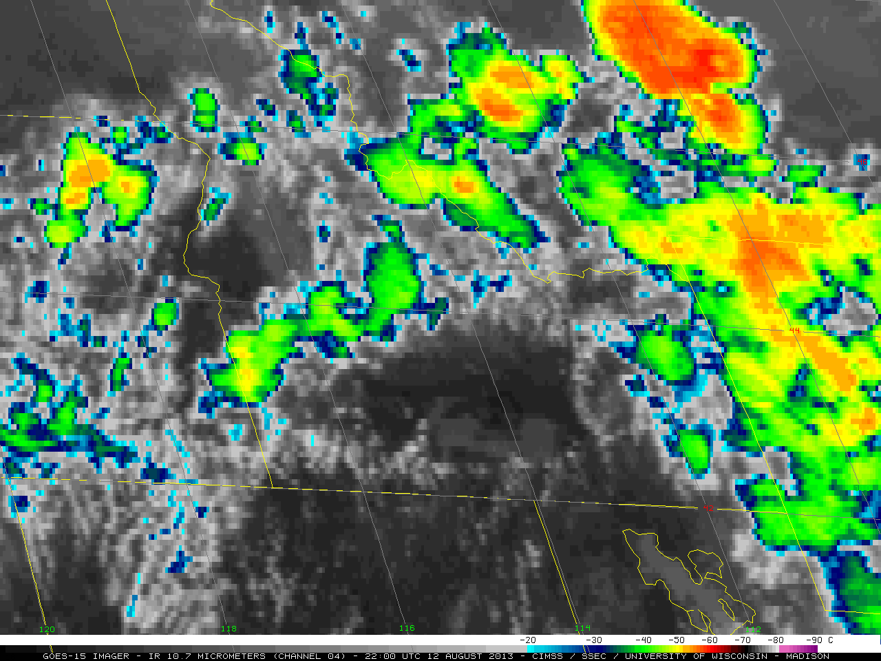
The corresponding 4-km resolution GOES-13 10.7 µm longwave IR images (below; click image to play animation; also available as an MP4 movie file) revealed that the pyroCb cloud top began to exhibit IR brightness temperature values colder than -30º C (cyan color enhancement) at 21:15 UTC, -40º C (green color enhancement) at 22:02 UTC, and a minimum value of -47º C (light yellow color enhancement) at 23:32 and 23:45 UTC as the pyroCb anvil drifted southeastward across Wyoming. The leading edge of the cold pyroCb cloud mass was located over the Wyoming/Nebraska border by the end of the animation at 02:15 UTC on 17 July.

GOES-13 10.7 µm IR channel images (click to play animation)

GOES-13 10.7 µm IR channel images (click to play animation)

A comparison of 1-km resolution NOAA-15 AVHRR 0.63 µm visible channel, 3.74 µm shortwave IR channel, 10.8 µm longwave IR channel, and false-color Red/Green/Blue (RGB) images (below; images courtesy of Rene’ Servranckx, CMC) provided a closer view of the fire source region and the pyroCb cloud at 00:27 UTC on 27 July. The coldest cloud-top IR brightness temperature was -49.5 º C (within the green color-enhanced area), 2.5º C colder than what was seen less than an hour earlier on the GOES-13 IR images.

NOAA-15 AVHRR 0.63 µm visible channel, 3.74 µm shortwave IR channel, 10.8 µm longwave IR channel, and false-color RGB images

NOAA-15 AVHRR 0.63 µm visible channel, 3.74 µm shortwave IR channel, 10.8 µm longwave IR channel, and false-color RGB images

The southeastward-drifting pyroCb anvil was in the general vicinity of the Riverton, Wyoming upper air sounding site around 00 UTC on 27 July — a plot of the rawinsonde data for that time indicated that the -47º C temperature of the coldest GOES-13 IR pixel was located around the 235 hPa or 11.3 km level (where the wind was from the west-northwest at 71 knots). The tropopause appeared to be near the 124 hPa or 16 km level (where the minimum air temperature was -63.7º C).

Riverton, Wyoming rawinsonde data profile (00 UTC, 27 July)

Riverton, Wyoming rawinsonde data profile (00 UTC, 27 July)

HYSPLIT model 72-hour forward trajectories initiated at the location of the fire source point (below) showed a southeastward transport starting at the 11 km (coldest GOES-13 IR pixel height) and 13.5 km altitudes; at the 16 km height of the tropopause, the model indicated very little transport away from the fire source region.

HYSPLIT forward trajectories

HYSPLIT forward trajectories

—————————————————————————————————

OMPS Aerosol Index

OMPS Aerosol Index

On the following day (27 July), the Aerosol Index (AI) from the Ozone Mapping Profiler Suite (OMPS) instrument on the Suomi NPP satellite (above; courtesy of Colin Seftor) showed an area of elevated AI (as high as 3.2, darker orange color enhancement) centered over Kansas. This is consistent with smoke transport associated with the general northwesterly flow aloft over the central US on 26 July, between a ridge of high pressure over the Southwest US and a trough of low pressure over the western Great Lakes region (below), and was also in good agreement with the initial 18-24 hour HYSPLIT model forward trajectory transport paths at the 11 and 13.5 km altitudes.

500 mb height contours and winds

500 mb height contours and winds

Note that the leading edge of the 27 July OMPS Aerosol Index plume was arcing eastward over northern Alabama, in agreement with the 11 km HYSPLIT trajectory. The University of Wisconsin Lidar Group was operating their ground-based High Spectral Resolution Lidar (HSRL) at Huntsville, Alabama at that time, which detected an unambiguous signature of smoke at altitudes as high as 12 km late in the day on 27 July; subsequent lidar data indicated that the smoke layers then subsided into the middle troposphere during the overnight and early morning hours on 28 July (below).

HRSL backscatter and depolarization over Huntsville, Alabama on 27 July

HRSL backscatter and depolarization over Huntsville, Alabama on 27 July

HRSL backscatter and depolarization over Huntsville, Alabama on 28 July

HRSL backscatter and depolarization over Huntsville, Alabama on 28 July

—————————————————————————————————

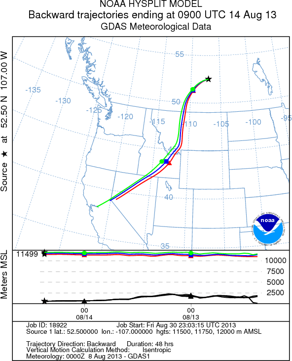
On 28 July, just after 07 UTC, the CALIPSO satellite made an orbital pass over eastern Canada (map) — the CALIOP lidar data (below) revealed the presence of a thin layer of smoke just above the cloud top (at an altitude of about 12 km), and HYSPLIT backward trajectories suggested that this smoke originated from the region of the 26 July Hardluck Fire pyroCb. The lidar total attenuated backscatter indicated a strong, young plume; the depolarization was fairly homogeneous at values less than 20%; the 1064/532 nm color ratio was distinct from the neighboring cirrus, and indicative of relatively small particles.

CALIOP total attenuated backscatter (circled: Hardluck smoke plume)

CALIOP total attenuated backscatter (circled: Hardluck smoke plume)

CALIOP depolarization ratio (circled: Hardluck smoke plume)

CALIOP depolarization ratio (circled: Hardluck smoke plume)

CALIOP attenuated color ratio (circled: Hardluck smoke plume)

CALIOP attenuated color ratio (circled: Hardluck smoke plume)

PyroCb Event in Northwest Territory, Canada

130708_G15_VIS_IR2_NWTERR_46_edited

130708_G15_IR4_NWTERR_46_edited

On 8 July 2013, a Pyrocumulonimbus (PyroCb) was detected by GOES-15 imagery in the Northwest Territory of Canada, just east of the Yukon Territory border and north of the British Columbia border. The above two images at 22:30 UTC show the PyroCb anvil in the visible wavelength, hot fire pixels in the Shortwave IR wavelength, and cloud-top temperatures of -40˚ C and colder in the Longwave IR (for the feature circled in red). The feature circled in white is a possible second PyroCb event. We don’t know if the event in white is a result of a PyroCb from the nearby fire or a normal convective cumulonimbus cloud.

GOES-15 Visible and Shortwave IR images (Click image to play animation)

GOES-15 Visible and Shortwave IR images (Click image to play animation)

On the GOES-15 Visible and Shortwave IR images (above, click image to play animation) a number of fire hotspots were detected beginning at 20:00 UTC, followed by the development of Pyrocumulus clouds and an isolated PyroCb. Fire hotspots appear as black to red pixels in the Shortwave IR.

GOES-15 Longwave IR (Click image to play animation)

GOES-15 Longwave IR (Click image to play animation)

Using the GOES-15 Longwave IR imagery (above, click image to play animation), we were able to see the cloud-top temperatures associated with the PyroCb in the center of image (Latitude: 62.5 N, Longitude: 122.3 W) become colder than -40 ˚C  (green color enhancement) after 22:00 UTC and shortly died out after 23:30 UTC.


Terra and Aqua MODIS True Color images

Terra and Aqua MODIS True Color images

The animation above is true color images from our two polar orbiting satellites, Terra and Aqua. One image is from the morning and the second image is from the afternoon. Two fires are located at 62.5 N, 122.3 W in the center of the images and the third fire is located at 62 N, 121 W, southeast of the two center fires.


Fires in western Quebec

GOES-13 0.63 µm visible channel images (click image to play animation)

GOES-13 0.63 µm visible channel images (click image to play animation)

Large fires had been burning in the Eastmain region of Quebec since the middle of June 2013, and on a number of days produced large amounts of smoke. One such day was 04 July 2013, when 1-km resolution GOES-13 0.63 µm visible channel images (above; click image to play animation) showed several dense plumes of smoke, along with the development of a pyrocumulonimbus (pyroCb) cloud  after about 21:55 UTC. A well-defined pyroCb anvil casting a shadow on the smoke layer below was seen on the 23:02 UTC image.

The corresponding 4-km resolution GOES-13 3.9 µm shortwave IR images (below; click image to play animation) revealed widespread fire “hot spots” (dark black to red pixels) that increased in areal coverage during the day.

GOES-13 3.9 µm shortwave IR images (click image to play animation)

GOES-13 3.9 µm shortwave IR images (click image to play animation)

4-km resolution GOES-13 10.7 µm longwave IR images (below; click image to play animation) showed that the IR brightness temperature of the developing pyroCb cloud became colder than -20 C (cyan color enhancement) after 22:15 UTC, and eventually exhibited cloud top IR brightness temperatures around -40 C (green color enhancement).

GOES-13 10.7 µm longwave IR images (click image to play animation)

GOES-13 10.7 µm longwave IR images (click image to play animation)

On the following day (05 July), a 500-meter resolution Terra MODIS false-color Red/Green/Blue (RGB) image created using MODIS bands 07/02/01 (below) showed several very large burn scars (red-to-brown in appearance, in contrast to the surrounding green live vegetation) — it has been estimated that over 5000 km2 has been burned by these wildfires so far.

Terra MODIS false-color Red/Green/Blue (RGB) image

Terra MODIS false-color Red/Green/Blue (RGB) image


Carpenter 1 Fire west of Las Vegas, Nevada

GOES-15 0.63 µm visible (left) and 3.9 µm shortwave IR (right) -- click image to play animation

GOES-15 0.63 µm visible (left) and 3.9 µm shortwave IR (right) — click image to play animation

The Carpenter 1 Fire (InciWeb) was started by lightning in the Spring Mountains west of Las Vegas, Nevada on 01 July 2013. Three days later, on 04 July 2013, a comparison of GOES-15 (GOES-West) 0.63 µm visible channel and 3.9 µm shortwave IR images (above; click to play animation) showed the development of a large pyrocumulonimbus (pyroCb) cloud on the visible imagery, along with a distinct fire “hot spot” (cluster of red pixels) on the shortwave IR imagery (early in the animation, the dry and sandy desert land surfaces also appeared very hot during the afternoon hours and thus exhibited red-enhanced pixels).

The corresponding GOES-15 10.7 µm IR channel images (below; click to play animation) showed the very rapid spread in areal coverage of the pyroCb cloud top, which exhibited IR brightness temperatures as cold as -67º C. Also note the appearance of a fire “hot spot” (darker black pixels on this color enhancement), which is unusual to see on longwave IR imagery (unless the fire is extraordinarily hot).

GOES-15 10.7 µm IR channel images (click image to play animation)

GOES-15 10.7 µm IR channel images (click image to play animation)

According to the 07 July 00 UTC rawinsonde data from nearby Las Vegas, Nevada (below), the altitude of the -67º C air temperature was near 14 km; the tropopause was slightly higher in the atmosphere (around 15 km), with an air temperature of -69º C.

Las Vegas, Nevada rawinsonde data profile

Las Vegas, Nevada rawinsonde data profile

HYSPLIT model 72-hour forward trajectories (below) suggested an initial northeastward transport of smoke aloft during the following 24-36 hours, followed by an anticyclonic transport curving toward the south over the central US.

HYSPLIT model 72-hour forward trajectories

HYSPLIT model 72-hour forward trajectories

===== 05 July Update =====

An obvious increase in the size of the night-time fire hot spot (black to yellow to red color enhancement) is seen in a comparison of Suomi NPP VIIRS 3.74 µm shortwave IR images just after 10 UTC (3 AM local time) on 04 July and 05 July (below).

Night-time Suomi NPP VIIRS 3.74 µm shortwave IR images on 04 July and 05 July.

Night-time Suomi NPP VIIRS 3.74 µm shortwave IR images on 04 July and 05 July.

 ===== 06 July Update =====

The Carpenter 1 fire continued to burn into 06 July. A nighttime comparison of a 4-km resolution GOES-15 3.9 µm image with the corresponding 375-m resolution (mapped onto a 1-km AWIPS grid)  Suomi NPP VIIRS 3.74 µm shortwave IR image around 09:40 UTC or 2:40 AM local time (below) demonstrated the advantage of higher spatial resolution for the task of accurately identifying the location of the active fire hot spots (black to yellow to red color-enhanced pixels).

GOES-15 3.9 µm and Suomi NPP VIIRS 3.74 µm shortwave IR images

GOES-15 3.9 µm and Suomi NPP VIIRS 3.74 µm shortwave IR images