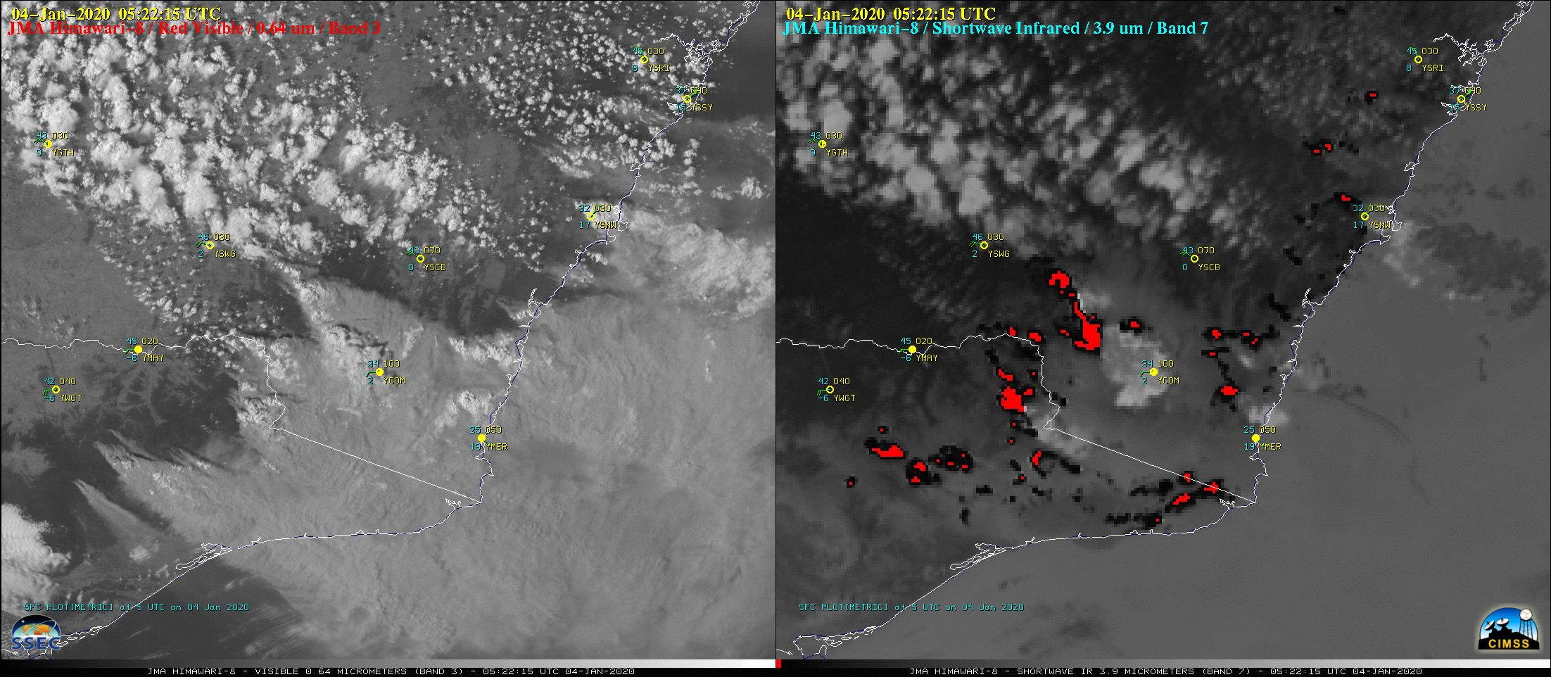
Himawari-8 “Red” Visible (0.64 µm, left) and Shortwave Infrared (3.9 µm, right) images [click to play animation | MP4]
Himawari-8 Shortwave Infrared (3.9 µm) and “Clean” Infrared Window (10.4 µm) images (below) showed the development of 2 pyrocumulonimbus (pyroCb) clouds — the first over southern New South Wales west of Cooma (station identifier YCOM), and the second to the southwest of YCOM (near the border between Victoria and New South Wales). The second pyroCb eventually exhibited cloud-top infrared brightness temperature (IRBT) values of -70ºC and colder (purple pixels). To be classified as a pyroCb, a deep convective cloud must be generated by a large/hot fire, and eventually exhibit cloud-top 10.4 µm IRBTs of -40ºC and colder (thus assuring the heterogeneous nucleation of all supercooled water droplets to ice crystals within the thunderstorm anvil).
![Himawari-8 Shortwave Infrared (3.9 µm, top) and "Clean" Infrared Window (10.4 µm, bottom) images [click to play animation | MP4]](https://cimss.ssec.wisc.edu/satellite-blog/images/2020/01/HIM08_SWIR_IR_TARGET_AUSTRALIA_PYROCB_04JAN2020_B713_2020004_090215_0002PANELS_FRAME00269.GIF)
Himawari-8 Shortwave Infrared (3.9 µm, top) and “Clean” Infrared Window (10.4 µm, bottom) images [click to play animation | MP4]
On 4th Jan a @Qantas flight between Melbourne – Canberra flew through a PyroCB: A large, energetic, thunderstorm triggered by the #AustralianFires, causing severe turbulence: https://t.co/VvrsStWXK9
Here’s how it looked from space. Storm encounter was at approx. 07:47 UTC. pic.twitter.com/shuDaCk1ti
— SatWx Aviation (@SatWx_Aviation) January 6, 2020
Farther to the north, another pyroCb developed near Nowra, New South Wales (YSNW) — which briefly exhibited a -40ºC cloud-top IRBT at 0319 UTC, but then re-intensified around 08 UTC (below).
![Himawari-8 Shortwave Infrared (3.9 µm, top) and "Clean" Infrared Window (10.4 µm, bottom) images [click to play animation | MP4]](https://cimss.ssec.wisc.edu/satellite-blog/images/2020/01/HIM08_SWIR_IR_TARGET_AUSTRALIA_YSNW_PYROCB_04JAN2020_B713_2020004_031944_0002PANELS_FRAME00132.GIF)
Himawari-8 Shortwave Infrared (3.9 µm, top) and “Clean” Infrared Window (10.4 µm, bottom) images [click to play animation | MP4]
![Sequence of VIIRS True Color RGB and Infrared Window (11.45 um) images from NOAA-20 and Suomi NPP [click to enlarge]](https://cimss.ssec.wisc.edu/satellite-blog/images/2020/01/200104_03utc_04utc_noaa20_suomiNPP_truecolorRGB_infraredWindow_Australia_pyrocbs_anim.gif)
Sequence of VIIRS True Color RGB and Infrared Window (11.45 um) images from NOAA-20 and Suomi NPP [click to enlarge]
===== 06 January Update =====
![GOES-16 Natural Color RGB images + Smoke Detection derived product [click to play animation | MP4]](https://cimss.ssec.wisc.edu/satellite-blog/images/2020/01/g16_smoke_soam-20200106_112021.png)
GOES-16 Natural Color RGB images + Smoke Detection derived product [click to play animation | MP4]
In addition, GOES-17 (GOES-West) True Color RGB images created using Geo2Grid (below) showed a dense pall of smoke over the South Pacific Ocean (northeast of New Zealand). This was smoke from the 04 January outbreak of fires.
![GOES-17 True Color RGB images [click to play animation | MP4]](https://cimss.ssec.wisc.edu/satellite-blog/images/2020/01/GOES-17_ABI_RadF_true_color_2020006_193037Z.png)
GOES-17 True Color RGB images [click to play animation | MP4]
===== 08 January Update =====
![GOES-17 True Color RGB images, 05-08 January [click to play animation | MP4]](https://cimss.ssec.wisc.edu/satellite-blog/images/2020/01/202001081610_fulldisk.jpg)
GOES-17 True Color RGB images, 05-08 January [click to play animation | MP4]
